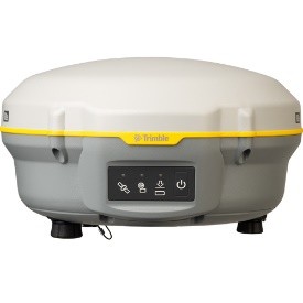
Description
PERFORMANCE SPECIFICATIONS1Measurements•
Advanced Trimble Maxwell 6 Custom Survey GNSS chip with 220 channels
• Future-proof your investment with Trimble 360 tracking•
High precision multiple correlator for GNSS pseudorange measurements
• Unfiltered, un-smoothed pseudorange measurements data for low noise, low multipath error, low time domain correlation and high dynamic response
• Very low noise GNSS carrier phase measurements with <1 mm precision in a 1 Hz bandwidth
• Signal-to-Noise ratios reported in dB-Hz• Proven Trimble low elevation tracking technology
• Satellite signals tracked simultaneously:
GPS: L1C/A, L1C, L2C, L2E–GLONASS: L1C/A, L1P, L2C/A, L2P–SBAS: L1C/A–BeiDou (COMPASS): B1, B2• SBAS: WAAS, EGNOS, GAGAN
Positioning rates: 1 Hz, 2 Hz, 5 Hz, and 10 Hz
POSITIONING PERFORMANCE2Code
differential GNSS positioningHorizontal ………………………………………………0.25 m + 1 ppm RMS
Vertical ………………………………………………..0.50 m + 1 ppm RMSSBAS differential positioning accuracy3 ……………………..typically <5 m 3DRM
SStatic GNSS surveyingHigh-Precision StaticHorizontal …………………………………………..3 mm + 0.1 ppm RMSVertical ……………………………………………3.5 mm + 0.4 ppm RMS
Static and Fast StaticHorizontal …………………………………………..3 mm + 0.5 ppm RMSVertical ……………………………………………..5 mm + 0.5 ppm RMS
Postprocessed Kinematic (PPK) GNSS surveyingHorizontal ……………………………………………….8 mm + 1 ppm RMSVertical ………………………………………………..15 mm + 1 ppm RMS
Real Time Kinematic surveyingSingle Baseline <30 kmHorizontal ……………………………………………….8 mm + 1 ppm RMSVertical ………………………………………………15 mm + 1 ppm RMSNetwork RTK4Horizontal …………………………………………..8 mm + 0.5 ppm RMSVertical …………………………………………….15 mm + 0.5 ppm RMS
Initialization time5 ……………………………………..typically <8 secondsInitialization reliability5 ……………………………………..typically >99.9%
HARDWAREPhysical
Dimensions ………………….19 cm x 10.4 cm (7.5 in x 4.1 in), including connectors
Weight …………….1.52 kg (3.35 lb) with internal battery, internal radio and antenna3.81 kg (8.40 lb)
items above plus range pole, controller & internal radio
Operating
Temperature6 ……………………..–40 °C to +65 °C (–40 °F to +149 °F)
Storage Temperature. . . . . . . . . . . . . . . . . . . . . . . . . . . . . .–40 °C to +75 °C (–40 °F to +167°F)
Humidity …………………………………………………100%, condensingIngress
Protection ……………………..IP67 dustproof, protected from temporary
immersion to depth of 1 m (3.28 ft)Shock and vibration …………………………….
.Tested and meets the followingenvironmental standards:Shock ……………………Non-operating:
Designed to survive a 2 m (6.6 ft) poledrop onto concrete. Operating: to 40 G, 10 msec, sawtooth
Vibration ……………………………………….MIL-STD-810F, FIG.514.5C
Dowload Brochure


